Back قياس الأعماق Arabic Batimetriya Azerbaijani Батиметрия Bulgarian গভীরতামিতি Bengali/Bangla Batimetria Catalan Batymetrie Czech Batymetri Danish Bathymetrie German Βαθυμετρία Greek Batimetrio Esperanto


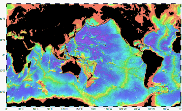
Bathymetry (/bəˈθɪmətri/; from Ancient Greek βαθύς (bathús) 'deep' and μέτρον (métron) 'measure')[1][2] is the study of underwater depth of ocean floors (seabed topography), lake floors, or river floors. In other words, bathymetry is the underwater equivalent to hypsometry or topography. The first recorded evidence of water depth measurements are from Ancient Egypt over 3000 years ago.[3]
Bathymetric charts (not to be confused with hydrographic charts), are typically produced to support safety of surface or sub-surface navigation, and usually show seafloor relief or terrain as contour lines (called depth contours or isobaths) and selected depths (soundings), and typically also provide surface navigational information. Bathymetric maps (a more general term where navigational safety is not a concern) may also use a digital terrain model and artificial illumination techniques to illustrate the depths being portrayed. The global bathymetry is sometimes combined with topography data to yield a global relief model. Paleobathymetry is the study of past underwater depths.
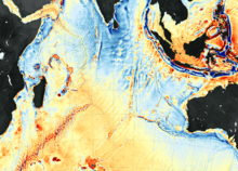
Synonyms include seafloor mapping, seabed mapping, seafloor imaging and seabed imaging. Bathymetric measurements are conducted with various methods, from depth sounding, sonar and lidar techniques, to buoys and satellite altimetry. Various methods have advantages and disadvantages and the specific method used depends upon the scale of the area under study, financial means, desired measurement accuracy, and additional variables. Despite modern computer-based research, the ocean seabed in many locations is less measured than the topography of Mars.[4]
- ^ βαθύς, Henry George Liddell, Robert Scott, A Greek-English Lexicon, on Perseus
- ^ μέτρον, Henry George Liddell, Robert Scott, A Greek-English Lexicon, on Perseus
- ^ Wölfl, A.C.; Snaith, H.; Amirebrahimi, S.; et al. (2019). "Seafloor Mapping – The Challenge of a Truly Global Ocean Bathymetry". Frontiers in Marine Science. 6: 283. doi:10.3389/fmars.2019.00283.
- ^ Jones, E.J.W. (1999). Marine geophhysics. New York: Wiley.